ISRO-NASA NISAR Launch Propels AI-Powered Earth Monitoring Revolution
NASA and ISRO's NISAR satellite, with its revolutionary dual-frequency radar, offers unparalleled Earth data, empowering AI solutions.
July 21, 2025
A landmark collaboration between the Indian Space Research Organisation (ISRO) and the National Aeronautics and Space Administration (NASA) is set to culminate in the launch of the NISAR satellite.[1][2] This Earth observation satellite, a testament to over a decade of joint effort, is scheduled to lift off from the Satish Dhawan Space Centre in Sriharikota.[1][2] The mission, officially named the NASA-ISRO Synthetic Aperture Radar (NISAR), represents a significant step forward in our ability to monitor the planet's dynamic surfaces and understand the complex processes that shape our world.[3][4] Weighing 2392 kg, the satellite will be carried into a 743 km sun-synchronous orbit by ISRO's GSLV-F16 rocket.[1] This ambitious project, with a total estimated cost of $1.5 billion, is poised to be the world's most expensive Earth-imaging satellite and will provide an unprecedented wealth of data with profound implications for science, disaster management, and the burgeoning field of artificial intelligence.[5]
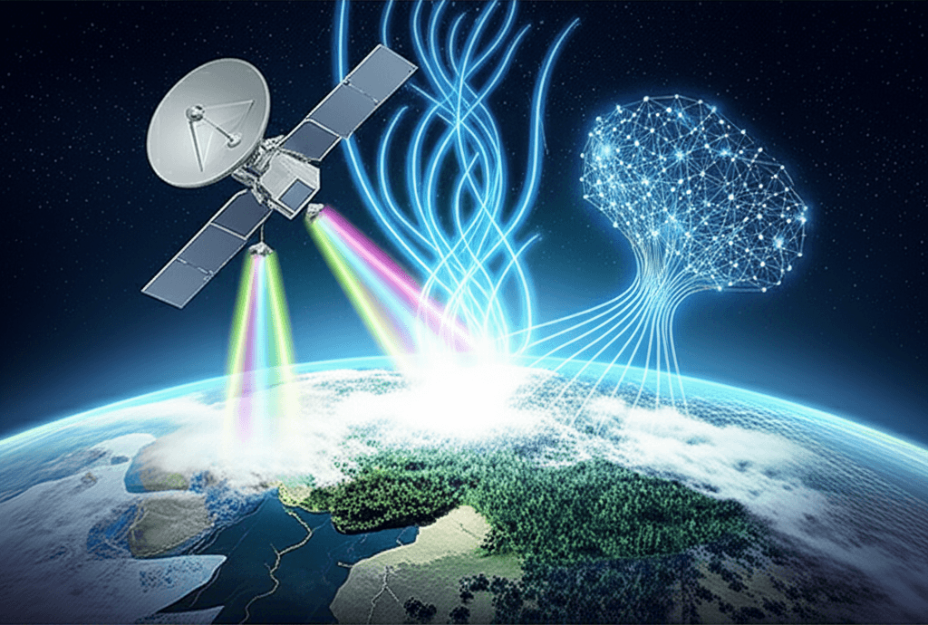
At the heart of the NISAR mission lies its cutting-edge dual-frequency Synthetic Aperture Radar (SAR) system.[3][5] This marks the first time a satellite will utilize two different radar frequencies, L-band and S-band, to systematically map our planet.[3][6] NASA has provided the L-band SAR, along with a high-rate communication subsystem, GPS receivers, and a solid-state recorder, while ISRO has contributed the S-band SAR, the spacecraft bus, and the launch vehicle.[7][2] This dual-frequency capability is a game-changer, allowing the satellite to penetrate clouds and even dense forest canopies to observe the Earth's surface regardless of weather conditions or time of day.[6] The L-band is particularly effective at penetrating vegetation to monitor landscape topography, while the S-band is optimized for tracking soil moisture.[6] With a massive 39-foot antenna reflector, NISAR will be able to detect minute changes in the Earth's surface, as small as 0.4 inches, providing data with a spatial resolution ranging from 3 to 48 meters.[7][6] This remarkable precision will enable scientists to monitor a wide array of phenomena with unparalleled detail.
The scientific objectives of the NISAR mission are vast and far-reaching, promising to revolutionize our understanding of Earth's ecosystems, ice masses, and solid Earth processes.[6][4] The satellite is designed to map the entire globe every 12 days, providing a consistently updated, high-resolution view of the planet over its three-year primary mission.[3][4] This rapid revisit time will allow for the tracking of dynamic events such as the movement of glaciers and ice sheets, providing crucial data for climate change research and sea-level rise projections.[8][9] NISAR will also monitor changes in vegetation biomass, deforestation, and agricultural land, offering vital information for resource management and food security efforts.[4][8] Furthermore, the mission will play a critical role in natural hazard assessment by monitoring tectonic plate movements, volcanic activity, and land subsidence, which can help in forecasting earthquakes and landslides.[7][8] The data collected will be invaluable for disaster response, allowing for rapid damage assessment in the aftermath of events like floods and hurricanes.[2][10]
The enormous volume and complexity of the data generated by NISAR will necessitate the use of advanced computational techniques, creating a fertile ground for the application and development of artificial intelligence. The mission's open data policy, making all L-band and S-band data freely and publicly available, will democratize access to this information and spur innovation across various sectors.[6][11] Machine learning algorithms will be instrumental in processing and analyzing the vast datasets, automating the detection of patterns and changes that would be impossible for humans to identify manually.[8] For instance, AI can be trained to analyze SAR imagery to monitor forest health, assess crop yields, and identify areas at risk of drought.[8] In the realm of disaster management, machine learning models can be developed to rapidly assess damage after a natural disaster, identify safe evacuation routes, and predict areas prone to future hazards like landslides.[8][12] The synergy between NISAR's data and AI will not only enhance our scientific understanding but also lead to the development of practical applications that can have a direct and positive impact on society. The mission is expected to generate a wealth of information that will be used to create new applications for water resource monitoring, infrastructure management, and more.[13]
In conclusion, the upcoming launch of the NISAR satellite marks a pivotal moment in Earth observation and international space cooperation. This joint endeavor between ISRO and NASA will provide a revolutionary tool for understanding our planet's complex and ever-changing systems. The unprecedented detail and frequency of its observations will not only advance our scientific knowledge of climate change, natural hazards, and ecosystem dynamics but will also fuel significant advancements in the field of artificial intelligence. By providing a free and open stream of high-resolution data, NISAR will empower scientists, researchers, and developers to create innovative AI-driven solutions to some of the most pressing challenges facing humanity, from mitigating the impacts of climate change to improving disaster preparedness and response. The legacy of NISAR will be not just the terabytes of data it collects, but the new era of data-driven, AI-enhanced environmental stewardship it helps to usher in.